


MORGANTOWN, W.Va. — The message is simple: if you don’t need to be out on the roads Friday night, stay home.
“If you do not have to leave when it’s dark, when it’s slick, when the bad weather is there, then stay home,” Morgantown Police Chief Ed Preston said Friday morning on WAJR’s Morgantown AM. “Don’t go out and drive in it. You could be a victim, and every time that we have to respond to somebody that gets themselves into a vehicle crash, it may take us longer to respond to somebody who might really need us.”
That’s because West Virginia is about to experience two different seasons worth of weather in less than 24 hours. The mid 60’s temperatures and accompanying rain will quickly be replaced as temperatures drop throughout the day.
“We’re going to have ice with snow on top of it,” Accuweather Meteorologist Elliot Abrams said Friday morning on Morgantown AM. “By about one o’clock in the morning, the temperature is going to be about 25 degrees after being 34 degrees at five or six this evening.”
Road conditions could be virtually impassable in non-treated areas Saturday morning, Abrams said.
“Temperature drops very quickly. We get the rain, some sleet, and then snow. It might sort of be like driving through cheesecake.”
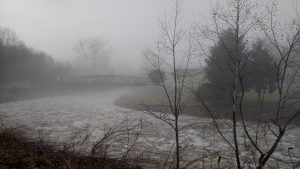
That’s on top of some localized flooding, flood watches, and even some flood watches that have extended from Friday morning into Friday mid-afternoon.
“We’ll have some more showers,” Abrams said. “We’ve had over an inch and a half of rain, generally some places more than two inches, which is about what we get in half a month. That’s why there is flooding.”
Late Friday night, the snow is expected to begin in parts of West Virginia — particularly in the North Central region. Abrams said he’s unsure on the amount of snow, but said the end result to roads should be about the same.
“Between seven and nine, it should become icy,” Abrams said. “We’ll be getting rain and sleet. After that it looks like it snows for a few hours. If it snows for six or eight hours, we’re going to wind up with five or six inches of snow. If it only snows for a couple hours, it’s only an inch or two. Either way, it looks like it has to get very slippery for a while during the evening hours.”
A flood warning has been extended to 2:30 p.m. Friday in parts of Ohio, Wetzel, Marshall, Brooke, Marion, Monongalia, and Hancock counties. A flood watch is in effect for those same counties and parts of Preston County into Saturday afternoon. A wider winter weather advisory goes into effect at 7 p.m. this evening until 10 a.m. Saturday morning.
The flood warning was extended by the National Weather Service due to ongoing flooding. The flood watch is in effect due to expected additional flooding due to the combination of rainfall and snow melt.